built 1809-1810
.

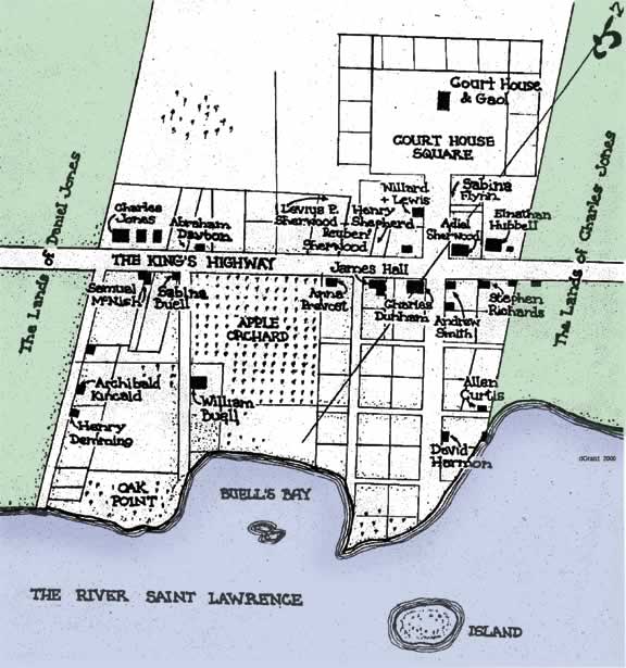
I drew this map based on the earliest discovered map of Brockville. At that time, in 1811, the village was officially known as Elizabethtown by the government of Upper Canada.
.
I would like to try to tell the story of the development of the District of Johnstown Court House in Brockville from the earliest period, using what information has been discovered to date.
.
For many years, I believe, we have been told a mistruth by earlier compilers of Brockville history. The story has been reprinted over the years that there have been three court houses build in Brockville. This cannot be substantiated by facts and I have come to believe that what was thought to be a second building was simply a renovation and addition to the first building.
.
The story goes back to about 1805 when a petition was first circulated in the central part of the District of Johnstown. This document asked the government to consider moving the Courts from the village of Johnstown to a more central location. Later in December of that year, having been signed by “William Buell, Daniel Manhart and 107 others,” this petition was submitted to the government at York.
.
The end result was to convince those in power that moving the Court House and Gaol to a more central location “near or about Mr. Daniel Jones’s mill in front of the 1st concession of Elizabethtown” was a good idea. This decision was made in 1808 and an act was passed on March 16th of that year, in spite of counter-petitions from the residents at the Edwardsburg end of the District near the village of Johnstown who were very upset with the suggestion.
.
The decision being made, a high piece of land offered by William Buell was chosen in June 1808, and plans were drawn up for the new Court House.
.
The cost for the new Court House was to be paid by canvassing the residents of the area for subscriptions. The job of collecting the subscriptions and the contract for construction was placed in the hands of Charles Jones (1781-1840). Jones was still just a young man at this time, but had lots of Loyalist and “Family Compact” connections.
.
A contract has been found made between the two representatives of the District Justices of the Peace, Solomon Jones and James Breakenridge, and Charles Jones. It is dated November 9, 1808 and describes the proposed building in these words: “sixty-three feet long by forty feet wide, the foundation are to be of stone and raised four feet above the ground, the wall of the first story to be twelve feet high of brick, and of the length of two bricks in thickness, the second and third stories to be twenty feet high, and the length of one brick and a half in thickness”. Also mentioned is the fact that they will pay Jones so much of the 800 pounds for the building as he could collect from the subscribers to the project, and after that they will pay the remaining amount outstanding.
.
The nine District Magistrates meeting in Quarter Sessions in May 1810, and led by chairman Joel Stone, ratified the deal and placed the funds in the hands of Charles Jones. For a nominal twenty pounds in consideration, Mr. Buell drew up a deed on May 16, 1810 to give to the Crown all the required land for a square (about four acres) and a wide road leading down to the river.
.
Another interesting document, dated January 13, 1809, has been found in the Archives of Ontario which describe the sub-contract for the new building. It was a contract made between Charles Jones, the general contractor, and Joseph Bryan a carpenter living in Augusta Township to perform the “carpenter and joiner work” involved in the “new brick Court House to be erected on the site in Elizabethtown” (at that time the government name for Brockville). The building was described as being “63 feet long and 40 feet broad, and in shape agreeable to the plan drawn by the said Bryan.”
.
Furthermore, Joseph Bryan was responsible for “framing all the timbers and joists and scantling for the support of the floors and roof, the making of all the window frames, the putting up of the cornice, boarding the roof and shingling the same, and covering the Octagon”. He was also to make “the outside doors and window sashes, and put up the columns in front”.
.
Charles Jones was responsible for the masonry work, stone foundations and brick walls which were to be completed by September 10th. Jones would also supply all the wood materials and nails needed by Bryan and his crew. The contract promised to pay Bryan a total of $984.00, in three instalments ending the following June, the proposed time of completion.
.
These two recently discovered documents provide much important details to give a description of this first Court House. It was to be a long three-storey rectangular brick building with windows on the sides, topped by a gable roof covered in shingles. In front of the entrance doorway we would see a number of columns, and it will be topped by a octagonal shaped tower. That is what has appeared in numerous drawn views up until the time it was replaced by the present Court House in 1842.
.

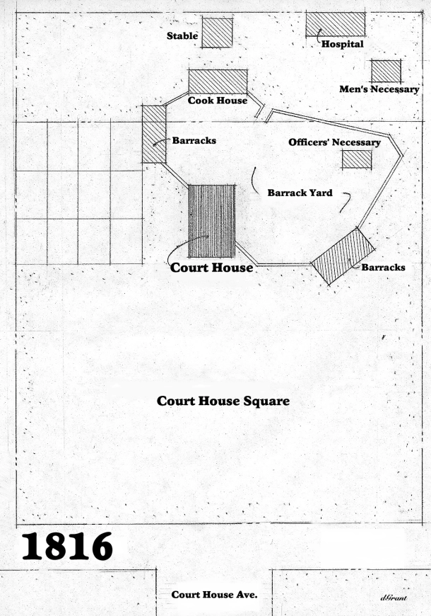
The area around the first Court House was used during the War of 1812-14 to house British troops and militia. This map shows the general placement of the various structures that were built in the Court House Square area. It is based on a plan from the period.
.

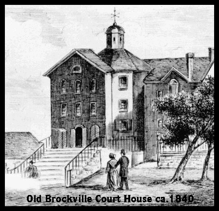
The only picture ever found of the exterior of the renovated old Court House, as it may have looked between 1824 and 1841. This drawing was one of a number of engravings of Brockville buildings in a special section of the Canadian Illustrated News on May 3, 1879. The first Court House shown here was replaced by the present one in 1842.
.

A notable artist who lived and worked in the Brockville area in the 1840s was Frederick Holloway. In this drawing done about 1840, he was able to accurately capture the town of Brockville, with the first Court House and the first three churches on the highest points of land.
.
Sources: History writing is problematic. It only works well when the true facts can be discovered. Otherwise myth may creep into what is passed on. I would like to thank those people who labour in Museums and Archives where insignificant scraps of information are filed and stored. The details I have used here are possible because of what was not thrown out in the past.


![King St W & Court House Ave [Brockville, ON] - Fulford Block (1974) King St W & Court House Ave [Brockville, ON] - Fulford Block (1974)](https://live.staticflickr.com/3066/2296519214_6d81b8c494_s.jpg)
![245a King St E (at Riverview Dr) [Brockville, ON] - Rockford, Sidney Jones House (1974) 245a King St E (at Riverview Dr) [Brockville, ON] - Rockford, Sidney Jones House (1974)](https://live.staticflickr.com/3066/2296516588_696c8bb19c_s.jpg)
![222 King St E [ Brockville, ON] - Patrick Murray House (1973) 222 King St E [ Brockville, ON] - Patrick Murray House (1973)](https://live.staticflickr.com/3166/2296515200_14e826d5e6_s.jpg)

